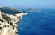
 The name of the island is without doubt Greek in origin, from Pharos (lighthouse). From it the Romans derived the name Pharia. The Dalmatian Romans then derived from this Fara, and the newly settled Croats in the early Middle Ages changed this to Hvar, as the old Slavonic consonant f was subsumed by the consonant group hv. The Dalmatian Romans, under the influence of Croatian pronunciation in the medieval documents spelt the name as Quara or Quarra. At the end of the 11th century the Italians called it Lesina, or in Venetian dialect Liesena or Liesna. This was derived from an old Croatian adjective meaning "forest", which actually corresponded to the appearance of the island at the time of the Neretljani. The eastern part of the island, Plame, has the shape of a cutting edge which gets narrower towards "the top of Hvar" and corresponds well to the medieval Venetian name Liesna which means "awl". This is what it looked like to the Venetian seamen who sailed past the island on their way to the Neretva Channel, near the massif of Krajina where threatening pirates were waiting in their lairs.A number of other island place-names describe its original wooded appearance. For example, Velo and Malo Grablje are derived from the word "grab" (hornbeam); Gin (a name identical to that of the Polish port of Gymea) also indicates a wooded place; Vrbanj and Vrboska are derived from "vrba" (willow), and Vrisnik from "vrijes" (heather). In the 3rd century BC the Hellenistic poet Apollonius of Rhodes introduced the name "Piteyeia", which is probably de rived from "pitys" Greek for spruce, or even from an old Illyrian name for the village of Pitve. The inscription recording the victory of the inhabitants of Pharos over the Jadasini and their allies, one of the oldest known inscriptions in Croatia, 4th C BC. Hvar belongs to the central island group of the Adriatic and lies in an east-west direction at right angles to the coast. These islands together are called "The Hvar Group". The eastern promontory of Hvar is only 4.5 km away from the mainland, while the western one faces the open sea. It is the longest of the Adriatic islands. "Lower Hvar", the western part, is called the "head of the island", as its main area. Plume - the eastern part - gets narrower towards "the top". Hvar (68 km long), is also the fourth largest in area (300 sq. m). The longitudinal road which links the town of Hvar with Sućurje at the eastern end of the island is 84 km long. The high plateau between St. Nicholas hill (626 m) and Hum (603 m) which extends from Sv. Nedjelja to Jelsa and is partly under pine woods and partly under arable land is marked by distinctive beauty and a fresh climate. The flat part of the island between Stari Grad, Vrboska and Jelsa is under vineyards which produce up to 50,000 hectoliters of wine per year.
The island is characterised by gentle winters, warm summers and many hours of sunshine, Gentle and moist winters (January Hvar has an average temperature of 8.4° C) have many advantages, long other things enabling winter tourism in Hvar. Maximum temperatures are never too high to render agriculture impossible (the highest recorded temperature of 37°C was reached in 1935). The average annual air temperature is around 16.5° C, while autumns are warmer than springs, which prolongs the growing period. Hvar has an annual average of 7.7 hours sunshine per day and 3.8 hours of cloud. (By comparison Dubrovnik has 7.0 hours of sun shine and 4.4 hours of cloud; Nice /South of France/ 7.2 and 4.2 respectively). A general belief in the health-giving effects of sunny regions led to the discovery of this "Adriatic Madeira" as early as the 19th century. It has the most hours of sunshine on the Adriatic coast, with as much as 2715 per year, and only small variations in temperature. "The Hygienic Society" was founded in 1868, and the first health hotel was opened in 1889, while The Centre for Allergies of the Croatian Academy of Arts and Sciences was founded in 1965. Due to its climate, Hvar has a long tradition iin health tourism and tourism in general.